
Trowse and Whitlingham
Policy POWHI1: Whitlingham Country Park plus adjacent land
- Whitlingham Country Park will continue to be managed to provide recreation and quiet enjoyment on land and water, supported by scenic landscape and wildlife habitat.
- Further development of buildings and facilities and sustainable recreation, leisure and appropriate visitor uses within the Country Park and areas adjacent to it (see Policies Maps), which contribute to these aims will be supported where they:
- Are of high-quality design and materials;
- Contribute positively to the river valley landscape and the setting of the Crown Point Registered Park and Gardens;
- Ensure no loss of parkland character;
- Avoid a proliferation of buildings in the area, and provide for shared use of these buildings where practicable;
- Improve provision for cycling and pedestrians (including convenient and well-designed cycle parking);
- Maximise access by water and public transport;
- Do not generate levels or types of traffic which would have adverse impacts on safety and amenity on Whitlingham Lane and the wider road network;
- Have assessed and addressed the impact of the proposal on existing uses, users or activities (on land and water) and on the quiet enjoyment of the area;
- Provide bio-security measures;
- Provide biodiversity enhancements;
- Ensure retention of woodland in the area;
- Contribute to the health and wellbeing of users;
- Address light pollution (see policy PODM27);
- As appropriate, link to the East Norwich Regeneration Area;
- protect existing nesting sites from disturbance resulting from an increase in access and recreational use;
- Do not impact Anglian Water Services assets in the area;
- Improve the visitor experience; and
- Support the sustainable management of the Park.
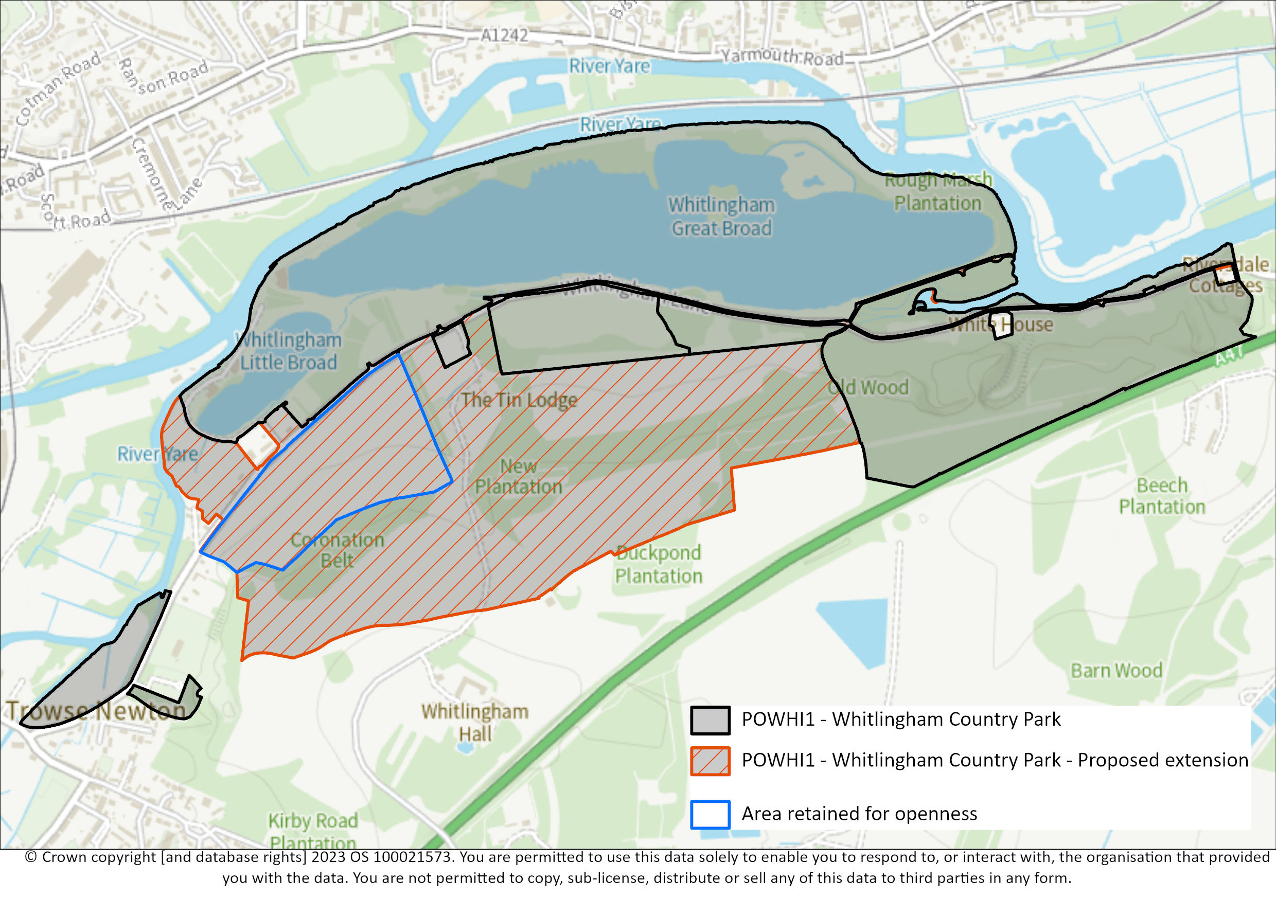
- The area marked in blue with yellow fill on the policies map will be left open, with no buildings.
- Any proposals that affect/relate to car parking in the area need to be thoroughly justified and based on assessment of the use of the car parks.
Constraints and features
- Area is adjacent to the Whitlingham Marshes Local Nature Reserve.
- Flood risk (mainly zone 3, some zones 1 and 2, by EA mapping; mainly zone modelled 3b, some 1, 2 & 3a, by SFRA 2017 mapping).
- Much of the land area is a registered park and garden.
- Adjacent and close to the East Norwich site which is allocated for development and change by Norwich City Council and the Broads Authority.
- Anglian Water Services assets in area.
Reasoned Justification
Whitlingham Country Park provides an area for quiet recreation, despite being so close to Norwich. Typical activities include walking, cycling, sailing and supervised open water swimming. There are also play areas, and a visitor centre and café in the Barn.
This policy reflects the importance of the Park to the Broads and local community, and encourages further enhancement of its facilities, while also setting out the constraints and considerations to address. The policy covers areas adjacent to the Country Park by the request of the landowners to support their vision of greater recreation use of the wider area.
‘Biosecurity’ means taking steps to make sure that good hygiene practices are in place to reduce and minimise the risk of spreading invasive non-native species. The type of water uses at Whitlingham Country Park range from rowing boats to canoes. These boats can be removed from the water and taken to other water bodies. Users should be aware of the good practice of ‘check, clean and dry’ to help stop the spread of invasive aquatic species. Of relevance is policy PODM5 on boat wash down facilities.
The Authority’s guide on biodiversity enhancements may be viewed here: http://www.broads-authority.gov.uk/planning/planning-permission/design-guides
The Park is a unique recreation offer close to Norwich. It is accessed by Whitlingham Lane, where there are residential dwellings and other recreation offers. The policy aims to make sure that levels of traffic will not impact on safety or amenity and seek improvements for pedestrians and cyclists to the Park. Any proposals for changes to the car parking provision on site need to be fully justified, using up-to-date assessments of the use of the existing car parks to determine the need for more parking.
Tawny owls and ground nesting birds currently occupy land within the extension area and are likely to be negatively impacted by the potential increase in recreational disturbance resulting in a biodiversity loss. The impact needs to be understood, considered, and mitigated.
Buildings will be specifically excluded from the area marked blue outline with yellow fill on the map; this is to reflect the openness of the land here and that there are extensive and sequential views along Whitlingham Lane which contribute to an understanding of the wider landscape.
Anglian Water Services have water supply and water recycling network assets within the proposed extension area, which are protected by easements and should not be built over. Given the small-scale nature of development and the focus on enhancing biodiversity and recreation opportunities, any connections or diversion requirements would be dealt with at the application stage when/if development proposals come forward.
Whitlingham Charitable Trust and Crown Point Estate have requested that the area to which the policy applies, be extended. The map that follows shows the proposed extension, as well as the existing policy area. The proposed extensions is the orange hatched area.
Specific Question 7: Do you have any specific comments on the extension to the area to which this policy applies?
Reasonable alternative options
Keep the original policy.
Amend the policy.
No policy
Sustainability appraisal summary
The following is a summary of the assessment of the policy and alternative(s).
A: Keep original policy: 9 positives. 0 negatives. 0 ? Overall positive.
B: Preferred Option - amend policy: 10 positives. 1 negatives. 0 ? Overall positive.
C: No policy: 0 positives. 0 negatives. 10 ?
How has the existing policy been used since adoption in May 2019?
According to recent Annual Monitoring Reports, the policy has been used and the application was in conformity with the policy.
Why has the alternative option been discounted?
Given the unique offer in this area as well as the area’s various attributes and constraints, a policy seems logical. The amendments seek to strengthen the policy as well as make it clearer. The additional area has been assessed through the HELAA and is deemed acceptable.
Policy POWHI2: Land at Whitlingham Lane
- The Authority will support the retention of the site as a boatyard.
- If a change of use is sought for the buildings, this will need to be thoroughly justified.
- If a change of use is thoroughly justified, the Authority supports conversion rather than demolition and new build.
- Following on from point 2 and 3 of this policy, proposals for a change of use will need to address each of these criteria:
- Conversion/improvement activities would need to be informed by a Preliminary Ecological Survey. Address light pollution, in line with the Dark skies policy;
- Include biodiversity enhancements in line with the Natural Environment policy;
- Ensure impacts on the highway are addressed as per the Transport section of this Local Plan;
- Link to and make the most of the East Norwich development proposals;
- Ensure adequate provision for walking, cycling and wheeling;
- Use water efficiently;
- Enhance the wider landscape setting of the site, including enhancing the road frontage;
- Address the requirements of the Design Guide[176] and policy;
- Rationalise to one point of access onto Whitlingham Lane;
- Accommodate the flood risk on the site; and
- Accommodate the nature reserve on the site.
- The appropriate reuse and enhancement of existing facilities at the former rowing club and boatyard (and smaller ancillary buildings on the site) for Class E[177] land uses may be supported, subject to other criteria in this policy and other relevant national and local plan policies, where this is compatible with the location of the site. The Authority may seek to apply conditions limiting the ability to change use to other uses within Use Class E without the need for planning permission.
Constraints and features
- Former rowing club and boat yard
- On the edge of Norwich
- Some smaller ancillary buildings
- Near to Whitlingham Broads
- Nearby semi-natural grassland
- Part of site is a nature reserve
- Part of site is at risk of flooding
- Early proposals for the East Norwich redevelopment suggest a bridge landing point nearby.
- Currently two site accesses onto Whitlingham Lane
Reasoned justification
The two main buildings on this site are the former rowing club building and a boatyard. The rowing club building has been empty for a little while now. The boatyard was being operated, but the operator sadly passed away. The Estate consider these circumstances provide an opportunity to bring the buildings into another use.
If proposals are for Class E land uses then these will be assessed in line with the sequential approach in the NPPF for town centre uses, as well as in line with Policy DM2.4 of South Norfolk Council’s Development Management DPD[178]. Class E land use category is quite wide in terms of the types of uses. Not all will be appropriate to this site. Indeed, those E class land uses that are also main town centre uses (see glossary of the NPPF) will need to be considered in light of the NPPF requirements as well as local retail policy.
As per the Retail Policy in the Local Plan, we have regard to/defer to the retail policies of our District’s Local Plan. Policy DM2.4 of South Norfolk Council’s Development Management DPD[179] seeks the sequential test on schemes of 200sqm. It also seeks an Impact Assessment on schemes of 500sqmand over. The former Rowing Club building in around 450sqm and the boatyard building is around 290 sqm.
The Authority seeks the retention of the buildings to reflect the embodied carbon and link to the previous uses of the sites. Existing buildings have potential as bat roost locations and the brownfield nature of the site plus nearby semi-natural grassland suggests potential for reptile interest and therefore ecological surveys will be required. Indeed, the Authority will seek appropriate biodiversity enhancements as part of any scheme.
The only other buildings in the vicinity are small-scale traditional Estate Cottages, built with vernacular materials in a traditional style and these would certainly be considered locally identified heritage assets; any proposals for this site will need to consider and address the design to reflect nearby uses as well as the Design Guide.
The emerging masterplan and SPD for the East Norwich Redevelopment Site show that a bridge could be put in place near to the site covered by this policy. Any scheme needs to consider this opportunity.
The Highways Authority have requested one access onto Whitlingham Lane, rather than the two that are currently there.
There are some smaller buildings on the site; appropriate uses of these smaller buildings that complement the main buildings, that also meet the policy requirements will be supported.
Reasonable alternative options
Do not have a policy
Sustainability appraisal summary
The following is a summary of the assessment of the policy and alternative(s).
A: No policy: 0 positives. 0 negatives. 14 ?
B: Preferred Option: 13 positives. 0 negatives. 1 ? Overall, positive.
How has the existing policy been used since adoption in May 2019?
This is a new policy.
Why have the alternative options been discounted?
Promoting the re use of buildings on this site would hopefully prevent buildings being empty for a long time.
[176] Being finalised at the time of writing. ↑
[177] Note: In the event that the Use Classes Order changes during the life of this Plan, then the closest new Use Classes to those previously categorised as E Use Classes as a whole will apply for the purpose of applying the above policy, provided such new Use Classes are reasonably similar to the ones being replaced. Should no similar replacement new Use Classes arise, then the description of E Use Classes as at the date of the adoption of this plan will apply for the purpose of applying this policy, and appropriate conditions or similar mechanisms will be used to enforce such provisions. ↑
[178] Development Management Policies Document – Broadland and South Norfolk (southnorfolkandbroadland.gov.uk) ↑
[179] Development Management Policies Document – Broadland and South Norfolk (southnorfolkandbroadland.gov.uk) ↑
No results were found