
Hoveton and Wroxham
It is important to be aware that the Wroxham’s Neighbourhood Plan was ‘made’ in 2019 and is part of the Development Plan and the policies it contains may be of relevance to proposals for this area of Wroxham.
Policy POHOV1: Green infrastructure
The identified significant areas of green infrastructure will be maintained and enhanced for their combined and respective contributions to the character and appearance of the village, the amenity of visitors and local residents, floodwater capacity and nature conservation.
Constraints and features
- Parts lie within the Wroxham Conservation Area.
- Most at serious risk of flooding, according to SFRA.
- Flood risk - zones 1, 2 & 3 by EA mapping and all 2, some 3a and some modelled 3b by SFRA 2017.
Reasoned Justification
This policy seeks to protect several areas of open space/green infrastructure. It is important to recognise that it is protecting their openness, and not specifically promoting public access to them - parts of the area covered by the policy have public access, but others are private and do not.
The area has four distinct parts:
- The first area is off Brimblelow Road, much of which is private garden and mooring, but which makes an important contribution to the landscape and amenity of the vicinity, is a visual and wildlife link to the open land (marshes and woodland) close to the east and is where significant development would not be acceptable because of flood risk and access/highway limitations.
- The second area comprises the extensive gardens of properties in Beech Road. The inclusion of the area in this policy is intended to provide greater clarity about what the Authority wishes to see here, and to avoid some recent developments creating a precedent.
- The third area is the public open areas along the riverside between Granary Quay (included) and stretching up past the pub, moorings, Visitor Centre, Railway Bridge, and a little beyond. Hoveton Parish Council has previously stated that it wished to see Granary Staithe kept open and accessible to the public for the enjoyment of both residents and visitors and as an asset on the northbound entry into Hoveton, and that this view is widely supported by feedback from residents.
- The fourth area is the public staithe, Trafford Memorial Ground, Caen Meadow area off Church Road. The area is remote from the development boundaries in this plan but very close to those of the development boundary in the current Broadland Local Plan, just across the road and outside the Broads Authority Executive Area boundary.
The wording of the policy is intended to highlight their common and combined value and treatment, while recognising the differences in their qualities and access.
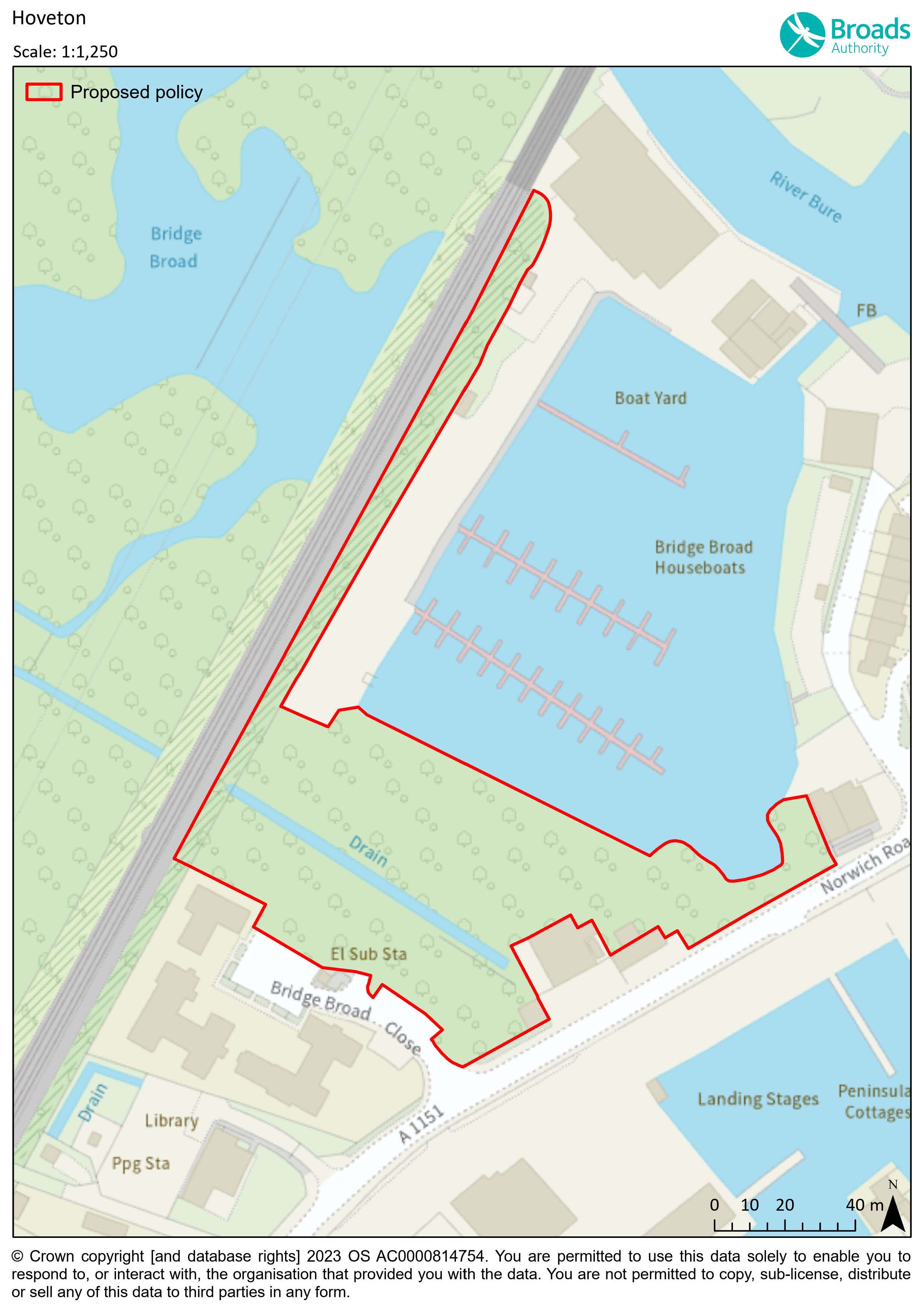
As part of the Examination into the current Local Plan, Wroxham Parish Council requested that an extra area of land be included in this policy. That request was not taken forward by the Planning Inspector. The area of land is shown on the following map.
Specific Question 4: What do you think about extending the area to which this policy applies to include the area of land shown on the following map?
Specific Question 5: Are there any other areas of green infrastructure in Wroxham/Hoveton that you would like to see protected?
Map showing the area of proposed LGS in Hoveton
Reasonable alternative options
No policy
Sustainability appraisal summary
The following is a summary of the assessment of the policy and alternative(s).
A: No policy: 0 positives. 0 negatives. 2 ?
B: Preferred Option: 2 positives. 0 negatives. 0 ? Overall, positive.
How has the existing policy been used since adoption in May 2019?
According to recent Annual Monitoring Reports, the policy has been used and applications have been determined in accordance with the policy.
Why has the alternative option been discounted?
The green infrastructure in Wroxham and Hoveton are part of the character of the area and so a policy that seeks their protection is favoured.
Policy POHOV2: Station Road car park
- This area will be retained in use for car parking.
- Environmental improvements, biodiversity enhancements and landscaping will be required to improve its contribution to the character and appearance of the area.
- Schemes will need to include appropriately located and well-designed cycle parking and electric vehicle charging points (of a suitable charging speed to reflect the demand in the area).
- Lighting will need to meet the requirements of policy PODM27 .
- Schemes will also need to address surface water (see policy PODM8).
- The Authority would expect an appropriate provision of disabled parking spaces.
Constraints and features
- Flood risk zones 1, 2 & 3 by EA mapping and some zone 2 by SFRA 2017 mapping.
Reasoned Justification
The availability of sufficient parking is a major factor in the continued success of businesses in the area and to the vitality of Wroxham and Hoveton. Given the nature of the hinterland, car use is the primary means of access to facilities for most people, and the present level of parking is important to maintain that access. The concentration of car parking here and elsewhere in the village also helps to reduce the clutter of cars in the wider townscape. That being said, the policy also seeks well designed cycle parking. In terms of light pollution and dark skies, design of any lighting will need to be well designed to meet the requirements of policy PODM27.
The policy also seeks appropriate biodiversity enhancements, given the car parks’ location next to Hoveton Riverside Park; the Biodiversity Enhancements Guide will be of relevance. Schemes are also required to include Electric Vehicle charging points as well as address surface water run off as per policy PODM8.
The Authority expects proposals to include an appropriate number of disable parking spaces. The policy does not set a standard or threshold for this requirement; it will be for the applicant to consider and justify their approach. The design of the disabled spaces will need to follow best practice. In terms of addressing any concerns relating to Crime, ParkMark may be of relevance.
Reasonable alternative options
The original policy, with no amendments.
No policy – it could be that other policies in the Local Plan are adequate.
Sustainability appraisal summary
The following is a summary of the assessment of the policy and alternative(s).
A: Keep original policy: 4 positives. 0 negatives. 0 ? Overall, positive.
B: Preferred Option - amend policy: 8 positives. 0 negatives. 0 ? Overall, positive.
C: No policy: 0 positives. 0 negatives. 8 ?
How has the existing policy been used since adoption in May 2019?
According to recent Annual Monitoring Reports, the policy has not been used.
Why have the alternative options been discounted?
The amendments to the original policy fundamentally reinforce the importance of the need for cycle parking, biodiversity enhancements and lighting impact to be addressed in line with other policies of the Local Plan and therefore are favoured.
Policy POHOV3: Brownfield land off Station Road, Hoveton
- The site is allocated for mixed uses that are appropriate to the site’s village centre location that is next to the river as well as next to a public house. The Authority would welcome a comprehensive scheme that covers the entire site to deliver a mixed-use scheme that takes advantage of this waterside location within the centre of the village and offers environmental and visual improvements.
- Proposals for this site off Station Road will need to address each of these criteria:
- A mix of uses that are appropriate to the location that strengthen the attractiveness of the village centre;
- Careful consideration will be given to the design, scale and layout of any redevelopment and potential additional impacts on nearby land uses;
- Improve opportunities for public access to the river;
- Improve connections and intervisibility between Station Road, the site and the river;
- Proposals must enhance the appearance of the area, including the public realm;
- Proposals must reinforce the relationship with the already established riverside walk;
- Part of the site is at risk of flooding and the type, siting and layout of development will need to take account of this in conformity with national policy;
- Appropriate measures to manage any risk of water pollution arising from development are required to be put in place;
- Proposals to provide car parking must be thoroughly justified and if the need is proven, must be well designed;
- Be designed to be energy and water efficient;
- Incorporate the trees and hedges around the site (see policy on Trees, Shrubs and Hedges);
- To reflect the riverside location of the site, policy on dark skies and light pollution will be of relevance; and
- Development proposals will conserve and where appropriate enhance the setting of the nearby Wroxham Bridge Scheduled Monument.
- The Authority acknowledges that due to its construction and poor condition, it is likely that the former Waterside Rooms building will need to be demolished. The Authority seeks the retention of the other buildings between the former Waterside Rooms and King’s Head on Station Road and the former coach buildings to the rear of the King’s Head building and would welcome a scheme for their refurbishment and re-use. See policy PODM2 on embodied carbon.
- Project Level Habitats Regulation Assessments will be needed to assess implications on Habitat Sites. If there is a residential element or overnight accommodation element to proposals for the site, proposals will need to mitigate recreation impacts, nutrient enrichment and may need to provide Biodiversity Net Gain.
Constraints and features
- Near to Wroxham Bridge, a Scheduled Ancient Monument.
- Land next to the King’s Head pub is partly in flood risk zones 2 and 3 according to EA mapping and former Waterside Rooms and former Broads Hotel Cottage site are partly within flood zone 2 again according to EA mapping. SFRA 2017 mapping shows some in zone 2 and very small parts of the allocation in 3a.
- Station Road and the footpath along the river run either side of these sites, which are en-route from the car parks at Hoveton and the railway station.
- Popular area for boats to moor.
- Successful King’s Head pub nearby.
- Former Broads Hotel site is in North Norfolk (this site has been cleared of buildings, but vegetation has grown back) linked to the Broads Hotel Cottage site.
- Potential for archaeological remains associated with the use of the adjacent River Bure.
- Protected trees on site.
- The site is in the Norfolk RAMs area.
- The site is in scope in relation to Nutrient Enrichment.
Reasoned Justification
This Local Plan seeks to address some redundant/underused or derelict sites around the Broads Authority Executive Area. Such sites can have a negative impact on the landscape, townscape, or waterscape and, if brought into an appropriate use, can become an important asset to the area.
The site off Station Road, Hoveton contains buildings that are either derelict underused and boarded up or have been demolished.
The former Waterside Rooms is a former public house which has been closed since the mid 1980’s and has fallen into disrepair. It is visible from both Station Road and the river, thus detracting from what is otherwise a popular and well-maintained area of Hoveton riverside. The policy seeks regeneration of this site. Demolition and redevelopment of this part of the site could be acceptable. Any scheme will need to be of the highest quality of design to reflect the prominent waterside location and the nearby collection of buildings associated with the King’s Head pub, also part of this policy.
The building next to the King’s Head pub is an interesting building with heritage value and has great potential for improvement and to be brought back into a beneficial use. The site could provide some holiday accommodation to compensate for the loss of the former Broads Hotel on Station Road, which was demolished, and the site redeveloped for car parking. The buildings are locally significant heritage assets and make an important contribution to the street scene and riverside at Hoveton. The Authority seeks to retain and reuse them, allowing the positive visual and heritage contribution they make to be enhanced. This building and the former Waterside Rooms are under the same ownership and a comprehensive scheme for the two sites considered together would be welcomed. This could also address the car parking at the pub, and the courtyard could be brought into better use to reflect its waterside location.
The policy lists some considerations relevant to the site, and other policies of the Local Plan are likely to be of relevance.
This area is very prominent, both from the river and from Station Road. Many people walk past these sites between either the car park or the station to the village centre, or along the river or by the road. Design, and how proposals fit with the public realm in the area, is of great importance.
This end of the village has many car parking spaces, with more on the other side of the railway, and the Authority is aware that some people would like to see more car parking in this area of the village. Any proposals for car parking for public use must be thoroughly justified through a car park assessment undertaken at peak times over a suitable time period, assessing weekend and weekdays. The proposals also need to be well designed, with safety a key factor.
The policy highlights the need for the scheme to ensure Biodiversity Net Gain in line with national requirements and policy PODM15. The scheme may also need to mitigate recreation impacts, and this is most easily done through paying the GI RAMS tariff as well as mitigate nutrient enrichment, depending on the uses developed on site.
Reasonable alternative options
No policy
The original policy, with no amendments.
Sustainability appraisal summary
The following is a summary of the assessment of the policy and alternative(s).
A: No policy: 0 positives. 0 negatives. 15 ?
B: Keep original policy: 12 positives. 0 negatives. 0 ? Overall, positive.
C: Preferred Option - amend policy: 15 positives. 0 negatives. 0? Overall, positive.
How has the existing policy been used since adoption in May 2019?
According to recent Annual Monitoring Reports, the policy has not been used.
Why has the alternative option been discounted?
The amended policy is preferred because it reflects better the early thinking of the scheme promoter for the sites. It also reflects the riverside location, the need for public access as well as referring to biodiversity and habitats regulation assessment issues.
Policy POHOV4: BeWILDerwood Adventure Park
- The retention of the park, as identified on the policies map, as an outdoor adventure and education facility will be supported.
- Ancillary development to meet the operational needs of the park, alterations to existing development and modest new development that supports the outdoor adventure and education facility will be permitted if the following considerations are satisfactorily addressed:
- impacts on individual trees and the woodland as a whole;
- impacts on protected species and habitats;
- adequate and appropriate provision of biodiversity enhancements (see policy PODM14);
- impacts on amenity of adjoining occupiers, including from changes in activities on site and opening times;
- traffic, transport, access and parking (including appropriate cycle parking provision and electric vehicle charging points as necessary);
- light pollution (see Policy PODM27);
- flood risk and water quality;
- ongoing management of the activities of the park to protect the trees, woodland, habitats, and species; and
- impacts on visual amenity and landscape character of the area.
- The outdoor adventure and education facilities shall remain within the existing main facility area (as identified on the policies map).
- Appropriate complementary diversification necessary to support the existing park may be acceptable, subject to consideration of the above points and other policies in the Local Plan and NPPF.
- The policies map identifies three main areas:
- The main area of the outdoor adventure and education park. In this area, retention and alteration of the existing play structures and other features will be broadly acceptable. Some modest new development may also be appropriate.
- The maturing woodland area is protected as a visual and amenity buffer. Small-scale park related activities, which do not result in adverse impacts, may be supported in this area; and
- The car parking and service areas will be retained in such a use.
Constraints and features
- Previous surveys have found BAP invertebrates, bats, breeding birds, otter, and water voles.
- There are large areas of wet woodland.
- Flood risk has changed over time. Previous FRAs have found parts of the area in Flood Zone 2 and 3. Much more is affected when considering climate change allowance. SFRA 2017 shows some of the area in flood zone 2.
- The Three Rivers Way walking and cycle route passes by the entrance to BeWILDerwood.
- The site is also home to The Norfolk Broads Cycling Centre.
- Contains cropmarks of field systems. Some of the boundaries may be Roman.
- An area of dark skies.
Reasoned Justification
BeWILDerwood Adventure Park is one of the major attractions in the Broads. There are treehouses, zip wires, storytelling, boat trips and marsh walks, and the BeWILDerwood education programmes offer cross-curricular activities. Being a unique and popular attraction in a special setting, a policy is deemed necessary to manage change in a way that seeks to protect and enhance the trees, species, dark skies, and amenity of nearby and adjoining occupiers. The park has continued to develop incrementally since first opening, but the trees and habitat are sensitive to the activities of the park. This policy also seeks to help the local community understand what may or may not happen in future.
The Park is required to be within the existing woodland because of visual, landscape and amenity impact.
The Horning Road access shall remain the primary access, with internal circulation on the track permitted by planning applications 2012/0038 and 2016/0063 and limited emergency and delivery access via Long Lane in accordance with planning applications 2012/0038 and 2016/0063. Any development that would result in an increase in visitor numbers should be served by appropriate sustainable transport options. Additional demands for on-site parking, if acceptable with regards to traffic and highway safety, would need to be carefully designed to integrate into the landscape and protect the amenity of adjoining occupiers.
All proposed development within the park should be assessed in line with BS5837:2012-Trees in relation to design, demolition and construction (or any successor standard). The policy seeks to make sure the management of the existing development and any future development takes account of the following impacts on trees:
- Reduction in tree cover
- Compaction of roots and associated impact on tree vigour
- Severance of roots
- Impact damage
- Tree protection during construction
- Comprehensive and sustainable woodland management
Regarding habitats around the site:
- The wet woodland habitat is the most important and species rich of the habitats on the site.
Any future development should avoid adverse impacts to wet woodland habitat and associated plant and invertebrate species. - Grassland is used by resident breeding barn owls for hunting and should remain available and managed as such.
- The woodland on the site supports many species including bats, birds and invertebrates, and some reptile potential such as grass snake. Any further development should consider protected species mitigation and enhancement.
The car parking lies outside these areas but is an important component of the development, and there are dedicated service areas. It would be appropriate to retain these uses in these areas. In terms of parking, the policy also refers to the need for appropriate provision of cycle parking and electric vehicle charging points.
Reasonable alternative options
An alternative option could be to have no specific policy relating to BeWILDerwood; any application would be considered using existing policies.
The original policy, with no amendments.
Sustainability appraisal summary
The following is a summary of the assessment of the policy and alternative(s).
A: No policy. 0 positives. 0 negatives. 8 ?
B: Keep original policy. 7 positives. 0 negatives. 2 ? Overall, positive.
C: Preferred Option - amend policy. 8 positives. 0 negatives. 0 ? Overall, positive.
How has the existing policy been used since adoption in May 2019?
According to recent Annual Monitoring Reports, the policy has been used and applications have been determined in accordance with the policy.
Why has the alternative option been discounted?
BeWILDerwood is an important tourism site in the area, set in an important context. It is an area with many constraints. By setting out the key considerations, the policy supports appropriate change at the site. The preferred policy is favoured as it emphasises the importance of dark skies, cycle provision and biodiversity enhancements.
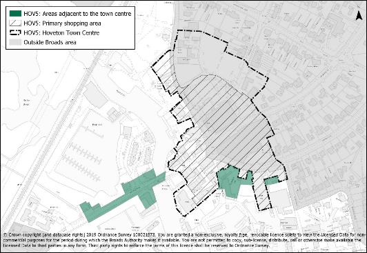
Policy POHOV5: Hoveton Town Centre and areas adjacent to the Town Centre
- For both areas identified on the Policies Map:
- Appropriate improvements to the quality of the public realm, in particular the river frontage and access to the river, will be supported.
- Residential uses will be supported only where they do not displace a retail, tourism or business frontage, or one that has potential to be such a frontage (e.g. residential could be potentially supported at first floor level or on a non-business frontage).
- Particular care will be taken to ensure that:
- developments do not significantly exacerbate traffic congestion and air quality problems
in the town centre, particularly in the vicinity of the bridge, and - the scale, massing, and external treatments, including advertising, contribute to the enhancement of the area’s appearance.
- developments do not significantly exacerbate traffic congestion and air quality problems
- Proposals will need to ensure they address other relevant policies in the local plan such as the natural environment, flood risk (with the potential need for a site-specific flood risk assessment) water efficiency, provide well designed and well-located cycle parking, consider the provision of appropriately designed and located EV charging points, consider overheating and provision of shade, consider crime prevention and safety measures and provide biodiversity enhancements if appropriate.
- The Authority may seek to apply conditions limiting the ability to change use to other uses within Use Class E without the need for planning permission.
The Town Centre
- Proposals in Hoveton Town Centre will be considered in the context of the entire town centre and the policies of the relevant North Norfolk District Council Development Plan so that retail and main town centre uses proposals address the town centre in its entirety.
- Hoveton Town Centre is identified as a medium town centre.
- Proposals for new retail and leisure growth, shop extensions, expansion and re use of vacant units for town centre uses will be supported as long as they:
- are of a scale appropriate to the size of Hoveton Town Centre;
- enhance the appearance and respect the character of the centre including its retail function and historic interest;
- enhance access to the Broads;
- assist in maintaining the existing retail function;
- meet the requirements of the overarching retail policies in this Local Plan (PODM34) and the relevant North Norfolk Local Plan; and
- contribute to the vitality and viability of the Town Centre.
- Retail uses will be concentrated in the Primary Shopping Area as defined on the policies maps of both North Norfolk District Council and the Broads Authority. Site selection for retail and other town centre uses should follow national policies and guidance.
- For Town Centre land uses outside of the Town Centre, a Sequential Test and Impact Assessment will be required. The Impact Assessment threshold for Hoveton Town Centre is locally derived and set at 500sq m gross.
- In addition to the NPPF requirements of impact thresholds (see 2023 NPPF section 7), any impact assessment must include an assessment on locally important impacts such as, but not limited to, access to the river, traffic flows over the bridge, the safety of pedestrians crossing Norwich Road, and the impacts on the provision of surface car parking.
The areas adjacent to Hoveton Town Centre
- Redevelopment of sites and buildings within this area will be supported where this provides retail, tourist or boating facilities that meet the requirements set out in a) to c) and i) to v). The safety of pedestrians crossing Norwich Road, and the impacts on the provision of surface car parking, are other important considerations.
Constraints/Features
- Actual Town Centre and Primary Shopping Area spans North Norfolk District Council and Broads Authority boundaries
- Localised congestion in the town centre and over the bridge into Wroxham.
- Hoveton Town Centre is classed as a Medium Town Centre in the emerging North Norfolk District Council Local Plan.
- Town centre is dominated by Roy’s Department Store.
- Town Centre extends to near to the river and riverside area.
- Part of the Town Centre has its own specific policy – see policy POHOV5, Land off Station Road, Hoveton.
- Flood risk from SFRA 2017 mapping: part 2, 3a and modelled 3b.
Reasoned Justification
This policy has been produced in coordination with North Norfolk District Council in recognition that the town centre needs to be considered as a whole. The following map shows the entire town centre, although the policies maps of North Norfolk District Council and the Broads Authority will show only that part of the Town Centre within their respective areas.
The intention of the policy approach is to ensure the town centre is considered as a whole. Proposals will need to consider the entire town centre and the policies of North Norfolk District Council so that retail considerations address the town in its entirety and cross boundary issues. This is especially important in applying the sequential and impact tests.
The North Norfolk Retail and Main Town Centre Uses Study (2017) supports the policy approach for Hoveton Town Centre as the shops in Hoveton are identified as trading below national levels and there is a low retention rate, especially for comparison goods, resulting in people spending money in Norwich. That being said, the town’s tourist role is equally important, and a broad mix of retail establishments is seen as key to maintaining the whole town’s vitality and viability. The shop vacancy rate in Hoveton remains low.
The Retail Study recommends that Hoveton Town Centre should not have Primary or Secondary Frontages. This is because of the dominance of Roy’s of Wroxham (i.e. a small number of large Class F2 units) and the predominance/scatter nature of tourist related facilities.
The sequential test (site selection process) for town centre uses outside of the town centre (NPPF2023 paragraph 91) needs to consider cross boundary policies and treat the town centre as a whole - and indeed Hoveton as a whole, rather than limited to the area within the Broads Authority Executive Area. It may be prudent to also include Wroxham as the two settlements adjoin each other. This floor space requirement is for the town centre as a whole and could be met in either of the Local Planning Authority Areas (or through a combination of sites in both).
A locally set threshold of 500 sq.m gross for the Impact Assessment would be appropriate for retail and leisure development in Hoveton/Wroxham, reflecting the existing scale of the town centre and the floor space projections[166] .
The 2017 North Norfolk District Council retail study identified limited potential to accommodate additional growth over the plan period, in the region of 1,234 gross sq.m. Since the study was completed, a permission was granted by North Norfolk District Council for 1357 sq.m of A1 and 550 sq.m of A3 in the Primary Shopping Area and Town Centre. This has effectively taken up identified available retail capacity in Hoveton Town Centre (as calculated in the retail study based on 2016 expenditure rates). Where necessary, further retail applications adjacent to and outside of the town centre are required to demonstrate if there is additional expenditure and capacity to support retail growth without significant impacts on other retail outlets in Hoveton Town Centre.
To prevent the proliferation of town centre uses in out-of-centre and edge-of-centre locations and to control their character, conditions will be used to restrict permissions granted for office, light industrial or research and development changing to other uses within Class E.
Policy PODM34 is the generic retail policy for the Broads and may be of relevance to proposals in Hoveton Town Centre.
Areas Adjacent to the Town Centre
Outside the Town Centre the policy makes provision for enhancement of the visitor experience to Hoveton/Wroxham and support will be given to redevelopment, in line with the policy requirements above, for the reuse and redevelopment in the identified adjacent areas. Although separated from the Town Centre and PSA, the areas adjacent to the Town Centre currently provide important visitor facilities and provide opportunities where investment could be directed.
Reasonable alternative options
No policy
Original policy
Sustainability appraisal summary
The following is a summary of the assessment of the policy and alternative(s).
A: Original policy: 8 positives. 0 negatives. 0 ? Overall, positive.
B: Amended policy: 12 positives. 0 negatives. 0 ? Overall, positive.
C: No policy: 0 positives. 0 negatives. 12 ?
How has the existing policy been used since adoption in May 2019?
According to recent Annual Monitoring Reports, the policy has been used and applications have been determined in accordance with the policy.
Why has the alternative option been discounted?
The Hoveton/Wroxham area is a honeypot of the Broads. There is much going on in that area. The town centre is shared with North Norfolk and therefore it is sensible to have a policy that complements that of North Norfolk Local Plan. A policy is therefore favoured.
[166] A threshold of 2,500 sq.m gross is stated in the 2023 NPPF (paragraph 94). The retail study concluded that this would be significant in relation to the scale of existing retail provision in Hoveton/Wroxham and is more than double the total floor space projection over the plan period. A locally set threshold is therefore adopted. ↑