
Norwich
Policy PONOR1: Utilities Site
- Redevelopment of this area will be sought to realise its potential contribution to the strategic needs of the wider Norwich area. The site is allocated for mixed-use development which could include around 271 dwellings.
- Redevelopment proposals will only be supported where they are in conformity with the East Norwich Regeneration Area SPD (to be completed) and where they:
- Do not prejudice but contribute to a comprehensive and deliverable mixed-use scheme for the whole of the Deal Ground/Carrow Works/May Gurney/Utilities Sites Core Area (including those parts outside the Broads Authority Executive Area boundary) known collectively as the East Norwich Regeneration Area;
- Protect and enhance natural assets and the historic environment and setting of heritage assets;
- Provide a high-quality local environment through high quality design and landscaping (see design policy and design guide[167]);
- Balance scale and massing of development, having regard to its location on the urban/rural fringe, and make a positive contribution to the views between the river and the site;
- Do not impede Norwich navigation;;
- Provide evidence, including a site flood risk assessment, to confirm that any development will be consistent with national and local policy in terms of both on-site and off-site flood risks;
- Provide a suitable and appropriate solution to the constrained access to the site for all modes of transport including the wheeling, pedestrian and cycle links through the site and linking to the wider network;
- Provide public access to the length of the Yare riverfront (see policy PONOR2);
- Are energy and water efficient;
- Identify, and provides remediation of, any existing ground contamination;
- Addresses amenity impacts from nearby existing land uses.
- Be resilient to a changing climate, particularly through providing shade and addressing surface water from intense rain bursts;
- Ensures any lighting meets the requirements of the light pollution policy (PODM27) to reflect the riverside location;
- Manage any risk of pollution of groundwater or river water arising from the proposed uses; and
- Make appropriate use of the safeguarded sand and gravel resources on the site where practicable (see Norfolk County Council's Core Strategy Policy CS16 - Safeguarding mineral and waste sites and mineral resources).
- As part of the scheme, the Authority expects a certain number of plots to be provided for self-build/custom build housing if this is viable and feasible in terms of the overall scheme. The precise number of plots will be discussed and agreed as part of the planning application process.
- Project Level Habitats Regulation Assessments will be required to ensure no adverse impacts upon any habitat site. Measures to mitigate for the effects of new growth will be required to mitigate for recreational disturbance and nutrient enrichment.
- The Authority will also expect the following to be delivered as part of the overall scheme, unless it is demonstrated this cannot practically be achieved:
- Improved opportunities for recreation on site;
- Improved facilities for recreational boating on the river frontage; and
- A pedestrian/cycle link across the Wensum and Yare between the City Centre and Whitlingham Country Park. A proportionate developer contribution will be required to address any increased demand on services and facilities in Whitlingham Country Park arising from the creation of this link.
- Applicants are encouraged to take the opportunity of using the proximity of the site to the river to use water source heat pumps or use the river for water source district heating.
Constraints and features
- Close to Norfolk County Wildlife Site – Cary’s Meadow.
- Likely to be of archaeological interest. Contains a range of heritage assets, including evidence for Roman settlement, a possible Roman wharf, and possible World War Two features and structures. Potential for archaeological remains associated with the use of the adjacent River Yare.
- Norwich navigation
- Flood risk - zone 2 by EA mapping and small parts in zone 2, 3a and modelled 3b by SFRA 2017 mapping. When EA climate change allowance of 65% added, site is affected.
- Contributes to the urban/rural transition.
- Semi natural habitat on the edge of Norwich.
- Future growth could have an impact on the foul sewerage network capacity.
- Access to the site is particularly constrained for all modes of transport.
- This site is in close proximity to a number of designated heritage assets including the Grade II listed Ruins of Trowse Newton Hall, the Thorpe Ridge Conservation Area and the Grade II listed Registered Park and Garden (RPAG) of Crown Point.
- Safeguarded sand and gravel resources
Reasoned Justification
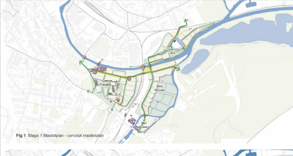
The site sits to the East of Norwich, yet on the urban rural fringe. In this area there is much brownfield redundant land that Norwich City Council and Norfolk County Council (in liaison with Broadland District Council, South Norfolk District Council and the Broads Authority) are keen to see redeveloped and realise their potential. The Utilities site is part of a much wider area of industrial land, now largely redundant, stretching across the planning boundaries of the Broads Authority, Norwich City Council and South Norfolk District Council. Over the river, to the south west, is the ‘Deal Ground’ site which has extant outline planning consent for a mixed-use development including 670 dwellings, a local centre, restaurant/dining quarter, flood risk management and landscape measures, a new access road, and an access bridge over the river Yare. To the West of the Deal Ground is the Carrow Works which was occupied by Britvic/Unilever but which has become vacant and has potential for redevelopment. The May Gurney site sits to the south of the Deal Ground site. This wider area is seen as having strategic development potential, but bringing development forward is complicated by access problems and the number of different landowners. The Joint Core Strategy (adopted 2011 with amendments 2014) identifies the East Norwich area as having major physical regeneration opportunities for mixed-use development and enhanced green linkages from the city centre to the Broads. The Greater Norwich Local Plan is being produced and allocates land at the Utilities Site, Deal Ground, May Gurney and Britvic/Unilever site and those policies will be of great relevance to any scheme that comes forward on the Utilities Site. Indeed, the Norwich City Council Site Allocations and Site Specific Policies Plan (adopted December 2014) has the following policies currently in place: R9: The Deal Ground, Trowse (residential led mixed-use development) and R10: Utilities Site, Cremorne Lane (mixed-use development).
The wording for this policy reflects, but simplifies and adds to, the content of the East Norwich Joint Statement produced by Norwich City Council in association with the Broads Authority and South Norfolk District Council. It also reflects the East Norwich Masterplan[168] and emerging East Norwich SPD. It is anticipated that the SPD, will be adopted by Norwich City Council, Broadland Council and South Norfolk Council as well as the Broads Authority in 2024.
The access constraints referred to in the policy reflects that the site is bounded by railway lines and a river. Whilst there are two ways to get to the site, the bridge over the railway to Cremorne Lane is not designed to cater for traffic that could arise from the redevelopment of this site and the access that runs alongside the river uses a tunnel under the railway bridge which again is not designed to cater for more traffic. The likely solution would be the provision of a bridge over the river that would connect the Utilities Site (in its entirety, not just the part within the Broads) to the Deal Ground site. The solution will need to take account of the navigation of the rivers Wensum and Yare, and Norwich navigation, as defined in The Norfolk and Suffolk Broads Act 1988.
The Environment Agency:
- supports the reference to the need to address flood risk issues, and highlights the need for Flood Defence Consent from the Agency for development and trees in proximity to the river;
- highlights the importance of protection against water pollution, that the site lies over groundwater resources and within Source Protection Zone 1, and the potential risks of water pollution from waterside sites in any industrial/boatyard uses; and
- draws attention to the potential of contaminated land.
Norfolk County Council identifies that the site includes a safeguarded minerals (sand and gravel) resource.
There will be a requirement for an evidence based project level HRA to assess the impact of this development on habitat sites. Mitigation measures will be required relating to recreation impact and nutrient enrichment – see the Natural Environment section for details.
There is potential for serviced plots to be provided for people to build their own homes as part of any residential element of the scheme. See self-build policy PODM50.
It is anticipated that the dwellings will be delivered after 2035, towards the end of the plan period. The Authority and partners consider that the site could potentially accommodate 271 dwellings.
In relation to the potential new link to Whitlingham Country Park, there could be more use of the park by residents living at the Utilities Site. The Authority appreciates that this link would make the Park more directly accessible to more visitors and that it benefits the wider existing community in the area, not just the residents of the Utilities Site. As such, an assessment of the increased number of visitors likely to visit the Park from the Utilities Site development will be needed. This will then determine the developer contribution required to enable the park to accommodate the additional visitors and demand on the services and facilities. The developer contributions sought would only reflect the visitors arising from Utilities Site development.
In terms of lighting, whilst it is acknowledged that the site is in Norwich, it is near a river corridor and these areas are foraging areas for bats and so lighting needs to be well designed, if required.
Reasonable alternative options
Original policy
No policy
Sustainability appraisal summary
The following is a summary of the assessment of the policy and alternative(s).
A: Original. 10 positives. 0 negatives. 0 ? 3+/? Overall, positive.
B: No policy. 0 positives. 0 negatives. 13 ? 3+/?
C: Preferred Policy. 13 positives. 0 negatives. 0 ? 3+/? Overall, positive.
How has the existing policy been used since adoption in May 2019?
According to recent Annual Monitoring Reports, the policy has not been used.
Why has the alternative option been discounted?
Considering the potential this site has and its role as part of the wider East Norwich Regeneration Area, it is prudent to allocate it. Indeed, this is supported by the HELAA. The changes are favoured as they add greater detail and clarity around requirements as well as opportunities the site offers.
Policy PONOR2: Riverside walk and cycle path
- Land will be safeguarded for a riverside walk and cycle path along the Wensum/Yare and implemented in a way which links to the wider network of public access in the area.
- Development of the walkway will need to address the archaeological and minerals potential of the area.
- The provision of appropriately designed and located art and its interpretation will be supported.
- Lighting will be designed in line with good lighting principles given the riverside location.
- Continuing the path to link to Carey’s Meadow (see policy POTSA1) is supported in principle, subject to the design and any impact on navigation and the natural environment.
- Proposals need to fit in with the East Norwich regeneration scheme and policy PONOR1.
Constraints and features
- Likely archaeological interest in the area (Roman wharfs, WW2 structures found in vicinity).
- Flood risk - zone 2 by EA mapping and small parts in zone 2, 3a and modelled 3b by SFRA 2017 mapping.
- Being next to the river, will need to consider impact on navigation.
- The earmarked route ends close to Carey’s Meadow.
- The earmarked route passes the Utilities Site (part of the East Norwich scheme) see policy PONOR1.
Reasoned Justification
Public access to the riverside along this stretch of the River Yare (from the confluence of the rivers Yare and Wensum to the railway bridge over the Yare) has long been a policy objective. This is included in the aspirations for the development of the Utilities Site but is proposed as an additional and separate policy so that this is clearly indicated as an intention even if the adjacent site is developed later, or in a way different to that envisaged by that policy. The policy intends for the path to be delivered in a way that complements the East Norwich regeneration scheme.
The Environment Agency highlights the need for Flood Defence Consent from the Agency for development and for any trees in proximity to the river.
In terms of lighting, whilst it is acknowledged that the route is in Norwich, it is along a river corridor and these areas are foraging areas for bats and so lighting needs to be well designed, if required.
Reasonable alternative options
The original policy, with no amendments.
No policy
Sustainability appraisal summary
The following is a summary of the assessment of the policy and alternative(s).
A: Keep original policy. 3 positives. 0 negatives. 0 ? Overall, positive.
B: Preferred Option - amend policy. 4 positives. 0 negatives. 0 ? Overall, positive.
C: No policy. 0 positives. 0 negatives. 4 ?
How has the existing policy been used since adoption in May 2019?
According to recent Annual Monitoring Reports, the policy has not been used.
Why have the alternative options been discounted?
The amendments to the original policy add further important considerations such as lighting, art and interpretation, the potential to link to Carey’s meadow as well as to complement the East Norwich regeneration scheme and these changes are favoured.
[167] Being finalised at the time of writing. ↑